Smarter Governance Starts with SEEDs

SEEDs provides LGUs with powerful tools to store, visualize, and analyze spatial data, turning insights into action for smarter governance.

A comprehensive program that provides LGUs with all the tools they need to make informed decisions

Unify your information into a single, reliable source for faster decision-making. Uncover insights by analyzing, visualizing, and correlating your data’s key attributes.

Mapping your way to better communitites

View LGU data through charts, graphs, and maps to present complex information in a clear and intuitive manner.


What is SEEDs for LGU?

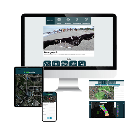
SEEDs (Social-Economic-Environmental-Demographic Information Systems) is a GIS-based platform designed to revolutionize local governance. Built for LGUs, SEEDs help store, visualize, and analyze spatial data, ensuring data-driven decisions for a brighter, more sustainable future.

SEEDs Core

Comprised of a management system and its geographic databases which makes use of geographic maps and other textual information to provide personalized and user centric functionalities.

SEEDs Admin

Users allows users to control content, user accounts, and modules for other users. Edit data attributes of the uploaded data in the database.

SEEDs Analytics

Allows users to select two (2) set of data layers and perform analyses for comparison and correlation between datasets.

Mission

To give Local Government Units (LGUs) the power to make smarter and more informed decisions for their citizens, and to empower good governance toward a resilient, more prosperous community—one data-driven decision at a time.


Vision

A growing network of local governments in the Philippines which use geospatial data and services for data-driven decisions and actions toward good governance.

Why choose SEEDs?


SEEDs fosters connectivity among government departments and offices by linking records across the local government to specific files or properties. Our approach centralizes records, making them easily searchable and ready for visualization which allows LGUs to enhance, among other things, the capability for:

  • SOCIAL: Planning, monitoring, and implementation of local government projects
  • ECONOMIC: Formulation of economic development plans and land use policies
  • ENVIRONMENTAL: Development of master plans for health and safety, risk and disaster mitigation, and other environmental policies
  • DEMOGRAPHIC: Efficient delivery of social services to its constituents with the aid of its demographic and socio-economic databases

SEEDs Modules

Populate

Upload and organize your LGU’s data effortlessly.

Catalogue

Access and manage data in a centralized repository

Map Portal

Visualize data with interactive maps, from hazard zones to land use.

Analytics

Perform advanced spatial analysis for deeper insights

Find the Perfect Package for your LGU

#

To achieve our mission, we provide cities and municipalities with three tiers of SEEDs, allowing LGUs to centralize records and visualize relevant data. Each package offers LGUs different approaches to decide smarter and faster.

SEEDs
(Basic Plan)

You get: A subscription-based SEEDs package valid for one year, ideal for LGUs starting their digital transformation.

Best for: Small LGUs needing foundational tools for data organization and visualization.


  • Yearly subscription
  • Technical support (Standard)
  • Up to 10 users, single-office
  • Up to 5 GB data per year data upload
  • Basic map layers and statistical analytics
  • One-time onsite training and full software walkthrough
  • Public viewing access through Guest function
  • Responsive design for mobile and tablet use
  •  
  •  
  •  
  •  
  •  


SEEDs Plus
(Enhanced Plan)

You get: A lifetime SEEDs software package with upgraded features for enhanced data management and visualization.

Best for: LGUs with large population and mega projects with existing IT infrastructure capable of handling complex governance challenges.


  • Perpetual license with one-time payment
  • Priority technical support
  • Up to 30 users, multi-office access
  • Basic map layers and statistical analytics
  • Fully customizable data management
  • Custom domain registration
  • Custom login page with LGU colors
  • One-time onsite training and full software walkthrough
  • Public viewing access through Guest function
  • Responsive design for mobile and tablet use
  •  
  •  
  •  
  •  

SEEDs Pro
(Comprehensive Plan)

You get: An enhanced lifetime SEEDs software and hardware bundle with upgraded features for a complete and powerful GIS solution.

Best for: Large LGUs ready to merge both the software and hardware components of SEEDs for enhanced and complete capabilities.


  • Perpetual license with one-time payment
  • Priority technical support
  • Up to 30 users, multi-office access
  • Basic map layers and statistical analytics
  • Fully customizable data management
  • Custom domain registration
  • Custom login page with LGU colors
  • One-time onsite training and full software walkthrough
  • Public viewing access through Guest function
  • Responsive design for mobile and tablet use
  • High-performance local server
  • Data storage and backup feature
  • Ready-to-use system
  • Uninterrupted operations
Working with a larger population?

For areas exceeding a city/municipality classification, please get in touch with our sales team.

Take the lead toward smarter and better governance. Book your Demo with us today!

Drive progress now through data-powered planning and governance.

Elevate your leadership, find out more about your tool to good governance.

#

Book a demo with us today!

#